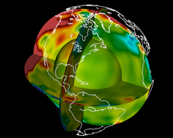
Mapping the Earth’s Interior Using Big Data
- Code: SPECFEM
- Science Domain: Seismology
- PI: Jeroen Tromp, Princeton University
Description
Jeroen Tromp of Princeton University and his team propose to create a high-fidelity picture of the Earth’s interior using earthquake data gathered from around the world. Leveraging the code SPECFEM3D_GLOBE and a technique called adjoint tomography, Tromp’s team has been able to image the Earth’s entire mantle on Titan. Summit will allow the team to dig even deeper – all the way down to the Earth’s inner core – and capture more detail by providing the extreme computational power necessary to optimize their code for seismic waves at periods approaching 1 second, the highest frequency signal that can propagate across the entire planet.


